India’s security is founded upon the core national interest of India, namely, to assure the material, economic and societal well-being of the people of India. The expression, “the people of India” presupposes the existence of a geopolitical entity called India, in which the people of India exist. Like every physical entity with a defined shape, the geopolitical entity called India is intimately tied to the concept of ‘borders’, and it is its territorial integrity that gives India its cartographic characteristics as a physically and politically recognisable sovereign nation-state.
The issue of sovereignty is impacted by several conceptual differences between the maritime borders of a nation-state and its land ones. The concept of a land border is a relatively straightforward one, and within the land borders of a State, sovereignty is absolute. Once the land border is reached, the sovereignty of one State ends and that of another begins. The main complications are limited to contestation of the border by another sovereign State.
The challenges of maritime borders
The exercise of sovereignty within the maritime context is a far greater challenge because, in the various legal regimes adopted by international law, sovereign jurisdiction dwindles (rather than suddenly disappearing) as one proceeds seaward from the coast. Thus, on the one hand, a territorial ‘border’ or ‘boundary’ that encloses a maritime belt within which State sovereignty is absolute does exist (although here too, States must concede some sovereignty to allow for the ‘innocent’ passage of international shipping). On the other, one must contend with additional maritime boundaries as well. These include boundaries that define the outer limits of maritime-zones that are contiguous to the sea-territory, but within which there are specified limits to the application of national laws; and, yet other boundaries that define the outer limits of areas in which sovereignty is limited solely to sovereign rights of exploitation of living and/or non-living resources.
Public perception of the country’s maritime boundary is, in and of itself, a challenge. Contrary to popular belief, the 7,516 km of our coastline does not define our maritime border. That border lies a further 12 nautical miles (nm) or 22.2 km to seawards — not seawards of our coastline, but of our internationally promulgated ‘baselines’ which, in some areas, do coincide with the low-water line along our coast, while in other areas, they do not. The sea-area enclosed between our baselines and this maritime border is our ‘Territorial Sea’. Here, the full majesty of India’s laws applies, with the notable exception of the Right of Innocent Passage.

The security conundrum
This Right of Innocent Passage within the territory of a nation-state constitutes a huge difference between land and maritime borders and, as may be readily imagined, brings in its wake a number of security challenges. For example, where foreign warships are concerned, India does not require prior permission to be sought, although prior notice is certainly required to be given, and submarines are required to navigate solely on the surface. It is reiterated that the waters of our ‘Territorial Sea’ are an integral part of the territory of India and every entity within it, if it is not a foreign-flag vessel engaged in ‘innocent passage’, is subject to every facet of Indian law to exactly the same manner as on land.

The UNCLOS has also created two additional jurisdictional zones, subjecting them to varying degrees of national jurisdiction. The ‘Contiguous Zone’ extends to 24 nm from the same baselines that were used for measuring the Territorial Sea. Within this zone, national legislation relevant to immigration, sanitation (health), customs and other fiscal matters is applicable.
The ‘Exclusive Economic Zone’ (EEZ) extends to a breadth of 200 nm from the same baselines. Within its EEZ, India has the exclusive right to explore and exploit all living and non-living resources on and under the sea, as also on and under the seabed. For countries such as India that have a ‘Continental Shelf’ that extends beyond 200 nm from these baselines, UNCLOS stipulates that the EEZ can be ‘pushed outwards’ to a maximum of 350 nm from the baselines, subject to certain hydrographic conditions being met.
Since each of these maritime zones have borders or boundaries that define their inner and outer limits, the challenges of guarding them and the sea-areas they encompass, are accordingly multiplied. Moreover, within the maritime domain, the term ‘border’, has a number of nuanced differences with land borders. For example, the maritime boundaries between India and Pakistan – not just the boundary that would delimit and delineate each country’s Territorial Sea, but also the one that would do so for each country’s EEZ – continue to defy resolution. The Sir Creek Boundary issue remains vexed not only because of Pakistani intransigence over the reference median line within the Sir Creek itself, but also because the final direction of the seaward extension of the boundary line will have an enormous impact on the EEZ area and its resources that will become ‘exclusive’ to one or the other country.
If one were to cross the land border of any given country, one would find oneself in another country – in other words, in a land area politically controlled by some State other than the one from which one came. This is not necessarily the case with maritime borders. If one were to cross a maritime border (the outer limit of a given State’s territorial sea), it is certainly possible that one might find oneself in the territorial sea of another, adjacent State that has a common territorial-sea boundary with the one from where one came. It is, however, also quite possible that one might find oneself in a sea area that does not belong to any State – in other words, in international waters.
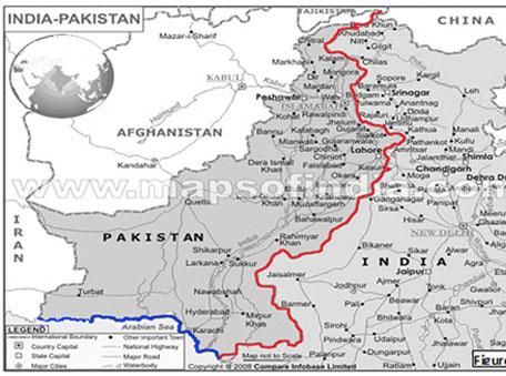
This has significant geostrategic overtones. For most of us, the border between, say, India and Pakistan (its disputed segments notwithstanding) is a thin wavy line that starts from Sir Creek and wends its way north-north-eastwards to the northern territories and the Siachen glacier. In the maritime context, however, the border between India and Pakistan is a thin wavy line that starts from Sir Creek and wends its way steadily westward, keeping 12 nm to seawards of duly promulgated and mutually accepted baselines, to Pakistan’s common maritime border with Iran! This is depicted in Figure 1.
It is obvious that when both these borders are considered, a number of new military-strategic challenges, as well as opportunities present themselves.
‘Moving’ neighbours
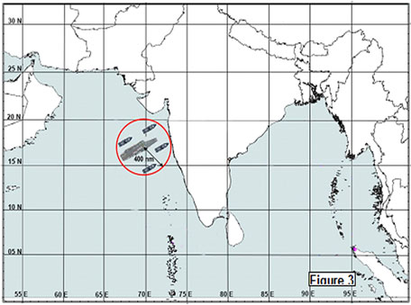
A further nuance of maritime borders is that a coastal nation-state like India can ‘acquire’ a new neighbour with unexpected speed. Take the case of a modern Aircraft Carrier Group (often called a Carrier Battle Group (CBG) or, sometimes, a Carrier Strike Group (CSG). This is a synergistic and mutually-supporting conglomerate of warships centred upon an aircraft carrier. The adjective ‘synergistic’ is particularly apt because the combat-capability of the group as a whole is almost always greater than the sum of its parts. Current technology allows a modern, Carrier Battle Group (CBG) to exert its power to a range of at least 400 nautical miles (740 km) around it. This circle may be considered to define an area of superiority within which the air and sea space may be said to almost ‘belong’ to the nation owning that Carrier Battle Group. To all practical (although not legal) intents and purposes, therefore, this is a moving area of ‘sovereignty’. When such a CBG’s ‘circle-of-superiority’ impinges upon, say, the Indian coast (as depicted in Figure 2), we have suddenly acquired a new and powerful ‘neighbour’ who may, as long as he remains where he is, even be superior to us.
Now we could choose to counter this superiority by building, say, an air-base at this point. However, such Carrier Battle Groups can move up to a 1000 km in a single day, and can disappear and appear with little or no warning.
It is, therefore, impossible to site relatively static defensive formations, such as airfields, cantonments, etc., all along our coast. This would be a prohibitively expensive way of maintaining the integrity of our maritime borders and is, in any case, a poor strategy, since the capability of maritime forces that are fundamentally mobile can only be countered by mobile maritime forces of our own.
Closely related to the whole concept of baselines and their legal implications is the subject of coastal security – one that has become increasingly vexed and emotive. Internal security involves the maintenance of law and order, where the laws in question are passed by due domestic legal and legislative processes, and enforced by the police. Since India is a democracy and not a military dictatorship, in the event of a breakdown of law and order, a specific flow-path comes into play which can only be allowed to run as follows:
‘State Police – Failed? – State Armed Police – Failed? – Central Police – Failed? – Central Armed Police – Failed? – Paramilitary Force – Failed? – Military’.
‘Failure’ could occur either because of a lack of ‘capacity’ or a lack of ‘capability’. It is important to differentiate between ‘capacity’ and ‘capability’. ‘Capacity’ is used in the context of ‘material’ wherewithal — i.e., the provision of hardware. For example, when the coastal police are given shallow-draught patrol boats with which to carry out patrols in coastal waters, this would constitute ‘capacity’. ‘Capability’, however, involves organisational, functional, attitudinal, and training-and-implementation procedures and processes, which will enable them to logistically-support, maintain, repair, and operationally deploy these boats. While the government can provide or augment ‘capacity’, each later echelon of the aforementioned flow-path can and must provide ‘capability’ to the earlier echelons. Thus, the Navy must provide such degree of ‘capability’ to the police as will enable them to move from ‘failure’ to success. Issues and imperatives related to coastal security are not limited to the Territorial Sea alone, nor are they restricted to actions by malevolent non-State actors. They extend throughout and beyond the maritime zones of India and this is why the Navy has been the overall responsibility for coastal security which, given that it is already facing significant operational stretch, is a challenge of no mean proportions.

 [/column]