div class=”excerpt”>The quaint backdrop of the sea, waters of a brackish lake lapping at your feet, the town of Pulicat fondly called Pazhaverkadu in Tamil, entices you with its large lake and its unparalleled history. Dotted with a few century-old mosques, temples of 11th and 13th century, churches dating back to the 1700s, the picture postcard town is a must-visit, if one appreciates nature and has an eye for heritage.
Text and photos: Text: Nivedita Louis
Why don’t we go on an impulsive trip? You will enjoy it”, queried one of our heritage group senior members, Venkatesh, and I nodded my head without batting an eyelash. A heritage trip on a peaceful Saturday, with like-minded enthusiasts – What more can one ask for? The plan was to meet at Parrys Corner, the most prominent landmark of North Chennai, and I was there well before time.
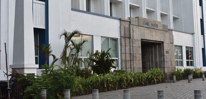
I gaze lazily at the pillar before the famed Parrys building – the Dare House that marked the boundary of the fortification the British made to protect the Esplanade from the French. The date of the masonry obelisk pillar reads, “Boundary of the esplanade – January 1, 1773”. As promised, one of our group members had come in early to show me the plaque erected in memory of the bombing of Madras by the ship SMS Emden on September 22, 1914. Though war clouds had threatened Madras so often during both the World Wars, it was this German light cruiser that actually managed to bomb the city, injuring a shepherd, his goat, and two others. The plaque can now be found on the compound wall of Madras High Court, near its beach road entrance.
Taking pictures of it, we then dig into idlis and sambar of the famed Murugan Idli Shop at Armenian Street, with gusto. “No food on the way till we reach Siruvapuri for lunch, an army marches on its stomach said Napoleon”, Venkatesh announces and chuckles, as we gulp down everything we can. Our journey commenced in two cars, and we drive past the seven wells – Chennai’s first regulated water supply system executed in 1772. A military residential complex stands at its place now as we whizz past and slow down at Ebrahim Street, Royapuram. Tucked away along the roadside is a small park with rickety gates, and a flight of stairs. As we climb over centuries of neglect, we are told this is the only remaining part of the North Wall of Madras, completed in 1772 by Paul Benfield. The wall ran for six kilometers and had 17 bastions at its height of glory, touted to protect the city from the French and Hyder Ali. Plans of further expansion were shelved after the demise of Hyder Ali and Tipu Sultan. Remnants of the wall remain even today, about 60 feet long, which is now called the Maadi poonga or the terrace park. Clicking a few pictures of the same, we continue our journey up north.
The 150-year-old Puzhal Lake
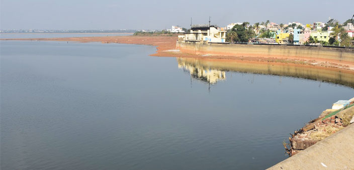
Our next stop is the Puzhal Lake – a reservoir that collects water from the Kortalayar River. Built in 1876, this water reservoir now stores water from Krishna and Telugu Ganga for use by Chennai city. We drive further north and reach the Shiva temple run by the Chinmaya Mission at Nallur village. The temple itself is built in a distinct structure of a giant lingam towering about 50 feet high. The acoustics at the temple mesmerises one. The priest’s ‘Om’ chanting reverberates in the entire structure, imparting a certain divinity to the surroundings. Though of no historical value, this stopover was spontaneous, and I am glad we did stop here, for the unique acoustic experience.
Our next stop is the air strip at Sholavaram. Sholavaram’s airstrip was used as a runway during the Second World War by the Royal British Air force for anti-submarine operations. The nondescript runway was later used as a race track for motor sport, till a new track was commissioned at Irungkattukkottai nearby. Now it has been closed for public and is being used by the military. With a cursory glance from the road, we proceed to Thamaraipakkam Check Dam.
The laterite checkdam
Built across the Kosasthalaiyar River, the huge laterite checkdam with weirs was constructed in 1868. It was extended later on, but unfortunately, not a drop of water could we see in the dam. What we did see is an abandoned PWD inspection bungalow dating back to 1915, the walls in good condition, but the tiled roof having given away. Careless garffitis deface the walls of the structure, which still boasts of large manicured shrubs along the entrances. I could very well imagine an engineer sitting on the verandah smoking his pipe, children playing around, and a cool breeze wafting from the dam. The original plaque erected during the opening of the dam lies on the dusty path, with the date inscribed, crying for attention. The automatic weirs must be a treat to watch, during the monsoons. Water from Korattalaiyar is stored here and diverted via Sholavaram and into the Red hills reservoir.
Our next stop is Tirukallil. The temple and deity of the Tirukallil Temple, Sivanandeswara, have found mention in the Devaram verses sung by Thirugnanasambandar, the Shaivite saint. Prayers in this temple bring fame and peace says his poem. The small tank in front of the temple – the Nandi Theertham is kept well-fenced. As we enter the temple, the priest calls out to us and performs aarti. I note tiny letters adorning the ceiling of the sanctum sanctorum which is in a queer hexagonal shape, now white washed with total disregard for whatever inscriptions remain etched there. As we roam around the temple, we strain and decipher successfully the name Kopperukesari Vikrama Chola (dating back to probably 12th century), beneath the old blue fading paint. There is another Pandya inscription too, which we are unable to read, our necks and heads reeling from the strain. The practice of painting everything saffron and white in our temples is a bane. We do not pay attention to what is beneath the paint. Conserving what little inscriptions and thereby history we have left with us, remains a distant dream, for we are totally unaware about how to preserve our heritage.
The Siruvapuri stopover and then, Pulicat
We are almost exhausted by now, as the afternoon sun blazes on. We pull over at Siruvapuri, planning for a hasty lunch, but end up spending an hour chit-chatting about Jimmy Carter and democracy. Past one o’clock, we drive towards our destination – Pulicat. Pazhaverkadu is a coastal town, much known for its 450 sq km salt-water lake and the migratory birds that flock there for much needed water and breeding. A bird watcher’s paradise, its close proximity to Chennai, about 59 km, makes it a great weekend destination. It can also be reached by train – it is 20 km by road from the nearest railway station, Ponneri. However, the history of the town is as rich as its eco-tourism.
Pulicat has been mentioned during the Chola period. The Thiruppalaivanam Temple six kilometre away from Pulicat, built by Rajendra Chola has inscriptions of Chola period (10th century) mentioning the coastal town as Puliyur Kottam, which in due course changed to Palliacatta, and then to Pulicat. It came under the rule of Vijayanagara kings during 14-17th centuries. It was under the rule of Krishnadevaraya that the port was named Pazhaverkadu, the name that holds water even today. Interestingly, during eighth century, a group of Arabs who escaped from the monopoly of Caliphate, fled from Medina and settled down at Pulicat. The descendants still live in the town today, called the Labbai clan. The unique Arwi script of writing Tamil in Arabic script probably originated here. Quite a difficult form of writing that was not easy to decipher, the writings in Arwi were used for secret communications during our freedom struggle. People in parts of south Tamilnadu and Sri Lanka still use this script for religious writings. From the Cholas, Vijayanagar kings, Portuguese, the town moved into the hands of the Dutch, during whose period it was a fort in all its glory, and then to the British, who treated it as their tourism spot. Pulicat was also home to the famed Palayacot lungies from which originated the famed Madras checks.
The Dutch Cemetery
The dusty lane that branches off from the main bazaar of the town leads us directly to the Dutch Cemetery at Kottaikuppam. The main gate is locked and as we look for clues, two men approach us from the nearby tea-shop. As we explain that we are looking for the cemeteries, one of them dangles the keys and opens up the gates for us. He remained our guide throughout the trip and was really proud to show us around the town. The gates lead to a semi-circular arch that has two skeletons inscribed on the sides. On the left is a Dutch verse and to the right is an inscription dated 1656. The impressive new cemetery is about 300 years old, and is at the south-west corner of the now extinct Geldria Fort. About 77 of them line up, in varying sizes and shapes, with distinct inscriptions in Dutch, Portuguese and English. The oldest of them probably dates back to 1646, and the latest one to 1777. Two obelisks stand majestically, and three more arched cemeteries add to the skyline. The inscriptions are complete with names of the buried ones, their age, the places where they were from, and the place and date when they died. It is interesting to find places like Rotterdam, Nagapattinam, Machilipatnam, Colombo, and obviously, Palliacatta, mentioned on the tombstones. The caretaker shows us a small opening in one of the cemeteries, a secret underground tunnel that is said to lead to the fort opposite the cemetery. The map of Fort Geldria is embossed on one of the tombstones! Opposite the cemetery is a vast wasteland, sluggish with backwaters, strewn with old brick walls, which the locals say is the old fort. Digging the place has been impossible, as the underground water immediately gushes out, when dug.
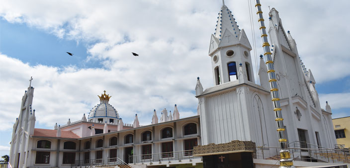
The next place of visit was the most interesting part of the tour for me – the Our Lady of Joy Church in Kottaikuppam. Touted as the first parish of the Roman Catholic Church on the Coromandel Coast, I am very eager to see the remnants of the old church. The massive concrete monstrosity before me almost stings my eye, as I race inside the church looking for even the most nondescript detail left by the church authorities during demolition of the old church. With disregard for the value of the old structure originally built by the Portuguese in 1515, the new structure is two-tiered, with no sign of the beautiful Gothic structure that once stood at this place. The inscription describing the church dating back to 1515 is also nowhere to be found. If found, the inscription could prove this as the oldest church on the Coromandel Coast, built a year before the Luz Church at Chennai in 1516.
Haggard and weary, we move to our next stop, the St. Antony’s Church, said to be built in the year 1717. The small but neatly painted church still maintains its Renaissance style, with tiled roof, high ceilings, windows housed in semi-circular arches, and large wooden doors. There is a small TV room nearby, a period attraction when village panchayats were provided with a television for the public to watch.
The ride on the lake
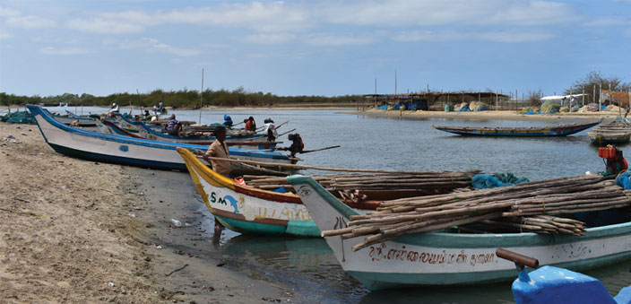
From here, we ogle at the large pottery jars placed in the courtyards of almost all the houses that hold drinking water. Soon, we reach the lake shores. From here, we board the fishing boat, a ride that cost us `1000, into the lake and from there to the sea. About 96 percent of the lagoon falls under the state of Andhra Pradesh, and the lagoon used to naturally open out into the sea. Due to heavy silt, now the lagoon mouth is dug manually, enabling it to join the sea. The Buckingham Canal is a part of the lagoon on the west, and three rivers – the Arani, Kalangi and Swarnamukhi, drain into the lagoon. Once rich with mangrove forests, now devoid of all greenery, the boat ride is all sweaty and salty on a humid February afternoon. With no shade or cover, I take shelter under my dupatta. There are old abandoned piers that show the date of construction as 1943, as the boat moves further into the lagoon. Slowly, the breeze ruffles our hair and birds start circling us. Sea-gulls, cormorants, storks, egrets, river terns…the colonies of birds attract us, and as we arrive at a tiny islet, where the boatman announces we can get off for a break and we jump out of the boat in awe.
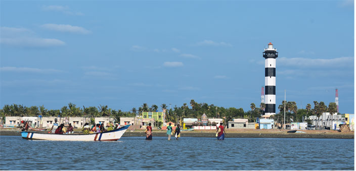
The small islet is a beauty, the shores lined up with conches and shells of various shapes and colours. It is a rainbow of colours on white sand, and the group gets all playful, clicking groupies, collecting shells, drawing on sand and gliding in the waters. The boatman has a tough time cajoling the history-buffs-turned-kids back to the boat, and the travel back is equally fascinating as we bounce in the water, disturbed by an armada of fishing boats venturing out into the sea for fishing. The light house at a distance attracts us, its dark blue and white hues standing in tall pride. The new light house was built in 1985, and was primarily built to warn of the shoals existing four nautical miles off the coast. It is separated from the town by a small channel. Our plea to get closer to the light house is warded off by the boatman who claims the sand bar is very shallow – about 30-40 cms, and is very dangerous to get close to the shore. Though disappointed, we agree to his warning and complete the boat ride.
The Chinna Masudhi, and the many temples
A coffee and fifteen minutes later, we find ourselves inside the Chinna Masudhi (small mosque). This mosque was built in 1708 as per the inscription just above the entrance arch, and its star attractions are an old 19th century azaan tower from which the Muzzein sang his prayer calls, and a sun dial belonging to the year 1914. The marking and inscription in the sun dial are in Persian script that reads the name of the installer as Haji Mohammed Hussain Saheb of Muthialpet, Madras. We try to decipher the language of the script and fail miserably, and I resign myself to watching a game of marbles being played by little boys.
We move to a dilapidated old temple next, called the Adhinarayana Perumal Temple. The temple probably dates back to either Vijayanagar period or to the late Cholas. There is an inscription in Telugu on the ceiling of the Thayar Sannidhi (sanctum mandap of the Goddess) that mentions about the period of Vijayanagar King Balavandakulu. The Dhwajasthamba, sacrificial pillar, and Garuda Sannidhi, stand in shambles, and so does the main temple. The outer Artha Mandapam is all that we can see, and we are spellbound by the intricate carvings on the supporting beams. Scenes from the Ramayana adorn the entire beam on all four sides, right from Ram’s Pattabhishekam (ascension to throne) to his vanvaas, the enticing of Sita by the deer Mareecha, Sita in Ashokvan, Hanuman meeting Sita, the war between Ram and Ravan in clear detail, the killing of Ravan, Sita entering the pyre, Lava-Kush and finally the happy re-union of the family. We stand mesmerised by the perfection of the tiny figurines on the beams and tread past the shrubbery into the Thayar sanctum. This resembles a mini Angkor Wat – the wilderness and trees eating into the space of the mandap, beautifully carved with mermaids, Ram with bow, dancing girls, monkey with jackfruit, Garuda and many many more figurines.
The temple was built with red laterite, which is endemic to the Konkan coast, and it is a surprise to find almost all temples of this area built using it. A haphazard effort has been made by the Hindu Religious and Charitable Endowments department to restore the temple using concrete and cement, which was quashed by the court on petition by concerned citizens. The temple is in danger of falling down anytime soon, the rank vegetation eating away its insides. Immediate intervention by ASI (Archaeological Survey of India) would be of much help to save this temple.
We move to the last stop of our trip – the Samayeswarar Temple. Said to be built in the same period as the Adhinarayana Temple, this Siva temple is also in a bad shape. The main entrance has trees crisscrossing the structure, and it looks as if it is the vegetation that is holding together the main entrance. We enter the temple through another side, distraught at the ‘restored’ new temple. Thankfully, the outer hall of the temple remains undisturbed, with pillars that have carvings like the Narasimha emerging from inside the pillar, a monkey hanging upside down on the pillar, Kannappa Nayanar and many more. Here too, the supporting beams have tiny figurines carved on them, and I am elated to spot a cow ringing a bell – depicting the story of Manu Needhi Chola, and the cow that came looking for justice to him. The various vahanas of the Gods lie in total abandon at the mandap and as we walk around the temple, to our left is a step well. Made of bricks and lime mortar, the circular well has an adjoining podium from which descend a flight of stairs into a tunnel, giving closer access to the water below. This is unique to the temple, as we have not seen this kind of arrangement elsewhere in Tamil Nadu temples. Tired, yet in a state of bliss, we head back home.
The town of Pulicat has a lot to offer other than the usual boat ride and fish fry. It has centuries of history waiting by the sands, for the enthusiastic traveler in us to discover. A natural harbour, the town celebrates an annual Pulicat Day, a few days after the World Wetlands Day, to stress the need for saving the delicate Pulicat lagoon. The lagoon and its ecosystem are under serious threat due to pollution and sedimentation. The moisture of the lake is not sufficient to attract the rain clouds, and there has been severe damage to the climatic balance. What is needed on the conservation of the ecological front is increased public awareness and governmental support. Conservation and protection of the historical sites is also imperative, if we want to pass on our rich legacy and heritage to our children.


